|
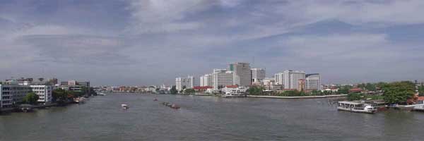
The Mae Nam Chao Phraya (River of Kings) is formed by the joining of the Ping and Nan rivers in central Thailand. It is the major waterway of the rice-growing regions of the country. The river runs through Bangkok from north to south, separating the old city, called Rattanakosin, from Thon Buri on the west. The picture above was taken from the Phra Pinklao bridge looking south. On the right side, you can see the entrance to the Bangkok Noi Khlong.
In the past, the river, with the adjoining canals or khlongs, was the principal method of transport in this part of Thailand. Today, roads and railroads play an ever increasing role, but the river is still important for hauling bulk cargos like rice and building materials. It is also filled with ferry boats (see photo #1, at left) hauling passengers up and down (and across) the river. The ferries are the fastest way to travel in this city of congested roadways. Some of the new roads cross the river on bridges, including this beautiful cable-stayed bridge.
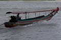
In addition to the many types of ferries, the long-tail boats (photo #2) provide transportation for small numbers of people, and can be chartered for a specific trip or by the hour. The long-tail boats have enormous engines mounted on gimbles so that they can be pivoted to steer. There are often a few long-tail boats queing up at the popular docks.
The passenger ferries and long-tail boats are generally very long and narrow. Some of them look very much like predatory fish. Getting on and off some of the ferries can be a bit of a challenge. We never had a problem making the leap, but it was something of an adventure at times. In fact, the ferries were our favorite way of getting around. We much preferred them to the traffic jams on the streets.
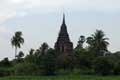
The ferries are a good way to see the sights. Often the river provides a better view of local landmarks than you can get from land (photo #3). The houses and shops along the river are built on stilts to keep them from being flooded during the rainy season when the river level rises.
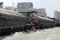
The river is also used to move heavy freight. We often see barges tied together in groups of four (or less) being towed by surprisingly small tow boats. The tow hook is very stylish. The barges are quite large, and can seem rather intimidating when passing very close by them on a long-tail or other small boat (photo #4). The older barges, which aren't seen much on the river today, were made of wood and were much smaller than the new steel boats. When they arrive at their destination, the barges are unloaded with a crane. In some cases, the whole process of unloading the barge, bagging the cargo, and loading it onto trucks, was taking place right on the dock.
Life along the river has its particular rhythms. The people who live and work on the barges make purchases from vendors who come alongside the barges as they are underway down the river. Dredges are at work in many areas to keep sediments from accumulating to form sand bars in the river. And, at buddhist temples along the river, people come to feed the river catfish. They gain merit by helping the animals. No one fishes near the temples.
The river provides a cooling influence in this tropical city. People come out to the riverside walks and parks in the evening to sit and talk, play games, and eat. Santichaiprakarn Park, near our guest house, is often full of people in the evening. Hundreds of people gather for an hour of dance exercise at 6:00 every night. Others perform traditional music, or pose for graduation photos along the waterfront.
Our local park contains Phra Sumane Fort, one of 14 forts originally built in the 18th century to defend the city's borders. Today the fort has been restored and is a local landmark. The park also contains a royal pavillon, a fairly new addition to the park. There is also a large sculpture depicting traditional activities, including musicians playing the same instruments as the performers we saw in the park.
— return to the 2004 Journal Archive
|