Death Valley Landscapes

March, 2005

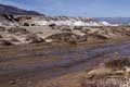
— Devil's Golf Course

The floor of Death Valley is a flat pan built up from sedimentary deposits of the soil that has washed down from the surrounding mountains. Lake Manly once filled the bottom of the valley, but dried up about 2,000 years ago. All of the salts that had been dissolved in the lake water were left on the surface of the sediments the form the valley floor. This is most apparent in the Devil's Golf Course (see photo #1, at left). The salt crystals form large clumps that are sharpened by the infrequent rains. The resulting spikes can be very sharp, and represent a real hazard to anyone who loses their balance while walking over this very rough terrain.

The Devil's Golf Course reputedly got its name because "only the devil could play golf on such rough links." We took great care while walking amongst the salt clumps. In some areas, where there was more water, we found tiny salt threads forming on the salt deposits. These would almost certainly be destroyed by rain, and we think they would not last during the extreme heat of the summer. We had been to Death Valley twice before, and never saw these little threads.

— Salt Creek

One day, we drove to Salt Creek (photo #2) to take part in a Ranger-led walk. Salt Creek is a partially intermitent, salty stream that is the home to a rare desert pupfish ( Cyprinodon salinus). During wet periods, the stream is the last home for these rugged little fish. During the summer, much of the stream dries up, and fish populations plummet. The survival of the pupfish seems to be always tettering on the edge.

With the ranger leading, we spent a relaxed hour or so walking along the streambed watching the male pupfish fight for territory (and females) so that they can breed quickly during the short time that the stream is at its full size. We walked along a boardwalk among the pickleweed plants and through a small valley that is the extent of the pupfish world. The whole thing is less than 1/2 mile long.

— Sand Dunes

The sand dunes are located in Mesquite Flats, north of Highway 190, just east of Stovepipe Wells. They are easily visible from the road (photo #3). The dunes are made of quartz and feldspar sands that started as rocks in the Cottonwood Mountains northwest of the dunes. The dunes are constantly being reshaped by the winds, so each time we visit Death Valley they look a bit different.

The dunes rise about 150 feet above the valley floor. They look dead and desolate from a distance, but they are home to a variety of animals and plants. The presence of plants can have an influence on the shape of the sand. Their roots hold the sand and prevent wind erosion. They also provide food and shelter for the desert animals that live here. The dunes look their best in the light of the setting sun, but we like visiting early in the morning when you can find the tracks of the many nocturnal creatures that live on the dunes.

— Ubehebe Crater

Near the north end of Death Valley, Ubehebe Crater (photo #4) was formed about 3,000 years ago. It is the result of a gigantic steam explosion created when ground water reached a hot layer of molten rock. The expanding steam carried away all the rock that once filled this 600 foot deep crater. On past visits, we scrambled down to the bottom of the crater. This time we decided to stay at the top. Old age, and memories of the climb back UP the crater wall, kept us from venturing below the rim.

The land around Ubehebe Crater is pockmarked with smaller craters. The whole area is heavily eroded, leaving an other-worldly landscape. We arrived just after dawn to get good light for photography. We enjoyed hiking around the rim of the crater to see the many sights, then drove on to reach Scotty's Castle before the crowds arrived. Because of the great wild flowers this year, the Park was rapidly filling up with more tourists than usual.

— return to the 2005 Journal Archive.