Go to Razzle Dazzle welcome page. Angkor, Cambodia
 

Angkor Temples 3


Introduction   |   2   |   3   |   4   |   5   |   6   |   7   |   8   |   9

October, 2004

Phnom Bakheng 10th Century ••• Bakheng Style Yasovarman I
 
Angkor photo.
Phnom Bakheng
nul.

"This is the most solitary place in all Angkor — and the pleasantest. If it was truly the Mount Meru of the gods, then they chose their habitation well. ... it is at sunrise and sunset that you feel its most potent charm."

— H.W. Ponder, 1936

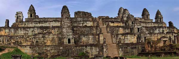
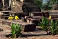
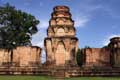
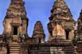
The temple of Phnom Bakheng was built on the top of a hill, carved from the native rock and faced with sandstone blocks. It was the center of a large city, the first Khmer capital in the Angkor area. The city was a 2.5 mile square, enclosed by a wall and covering 16 square miles. The temple is built on seven levels and originally included 108 towers, many of which have now collapsed. The central tower at the top of the temple is a ruin, but flowers still bloom in front of the sanctuary that it contained (see the photo at left).

The number and arrangement of the towers and levels correspond to Hindu numerology. For example, each of the five middle levels contain 12 towers representing the 12-year cycle of the zodiac. The seven levels represent the seven heavens of Indra. From each side of the temple, one can see 33 towers, which is the number of the Hindu dieties. There are many other such symbolisms throughout the design and decoration of the temple.

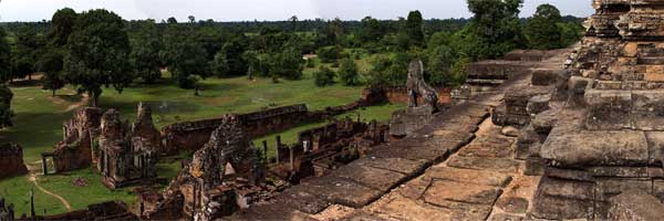
Tourists flock to Phnom Bakheng each afternoon for a sunset view of the surrounding plain, especially to see Angkor Wat rising out of the jungle nearby. In the early morning, when we climbed to the top of the hill and the temple, we had the place to ourselves.

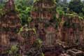
Here are some more photos of Phnom Bakheng, with a panoramic view of the temple below:

towers  | view  | sanctuary  | towers  | towers  | carving

 
Cambodia panorama.


Prasat Kravan 10th Century Bakheng Style Harshavarman I
 
Angkor photo.
Prasat Kravan
nul.

Prasat Kravan is a small temple consisting of five brick towers in a row on one platform (see the photo at left). The towers face to the east, as is typical for the temples of Angkor. The towers were rebuilt by the French in the early part of the 20th century. The exterior brick is almost entirely new, and can be identified by the initials CA (conservation d'Angkor) molded into the bricks. The interior brick walls of three of the towers contain original, and unusual, brick carving. The lintels and columns are the traditional sandstone.


East Mebon 10th Century •• Preah Rup Style Rajendravarman II
 
Angkor photo.
East Mebon
nul.

"The lovely temple of Mebon (is) a pyramid of receding terraces on which are placed many detached edifices, the most effective being the five towers which crown the top. Could any conception be lovelier, a vast expanse of sky-tinted water as wetting for a perfectly ordered temple."

— Helen Churchill Candee, 1925

East Mebon is distinctive for its location in the middle of a large baray, or water reservoir. The baray covered 14 square kilometers and was about 3 meters (10 feet) deep. The only access to the temple was by boat. Today, the baray no longer exists and has been replaced by rice paddies. The temple was built of laterite with sandstone trim and brick towers covered with stucco. Many of the brick towers have deteriorated badly over time .

The decoration at East Mebon is similar to that of the earlier temples in the Rolous Group. The lintels and false doors include many of the same design features, and there are elephants at the corners of the laterite terraces. This temple's water drainage system is still easily visible. Water runs through sandstone channels on each terrace to a serpent head spout to carry the water to the next level.

Here are some more photos of East Mebon:

entrance  | elephant  | pillars  | terrace  | view
doorway  | balusters  | elephant


Preah Rup 10th Century •• Preah Rup Style Rajendravarman II
 
Angkor photo.
Preah Rup
nul.

Preah Rup is an artificial mountain made of laterite blocks filled with earth. It is close in style, age, and location to East Mebon (above). The temple is enclosed in two enclosure walls and topped with five brick towers. There are also two sets of brick towers which frame the entrance to the temple (see the photo at left). There are 3 towers south, and 2 towers north, of the entrance. The northern base was clearly designed for a third tower. It is not certain if this third tower was ever built; the bricks could have been taken away for some other use.

The word rup means to turn or change, and may refer to a Hindu cremation ceremony. In this ritual, the body is outlined with ashes in various orientations. The name Preah Rup certainly gives this temple a funerary association, but its true function is still uncertain. It is definitely meant to symbolize Mount Meru, and its height offers great views of the surrounding country.

Here are ten more photos of Preah Rup, and a panoramic view from the top of the temple:

buffalo  | terrace  | view  | library  | statue bases  | halls
eastern hall  | lions  | doorway  | stairs

 
Cambodia panorama.
 

— return to the top of the page

— return to the 2004 Journal Archive


|    Welcome    |    Home Port    |    Tiki 38    |    Journal    |    Archive Index    |    Photos    |


Jim and Jamie Richter, http://gotouring.com/razzledazzle/
Website designed and created by Lois Richter, expanded by Jim.
Created 9/2004. All text & photos are © 2004 Jim Richter.