 |
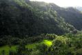
| The Boctol Valley. (90k)
|
|
 |
 |
| View from the top. (70k)
|
|
|
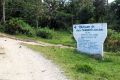 |
| Entrance to Calabacita (87k) |
|
|
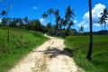 |
| The road to Calabacita. (78k) |
|
— Index —
|
Part 2: Jagna to Calabacita
From Jagna, Maria travels up the Boctol valley into the interior of the island. The road is unpaved, but was in generally good condition. It had rained a few days earlier and there were still some puddles in the road, but nothing that gave us any trouble. The road was still damp enough that we did not have any dust. When the weather is bad, the road can sometimes be impassable.
The Boctol valley is quite beautiful. The road winds its way among steep limestone cliffs. Wherever the land is flat enough, it is intensively farmed. We passed fields of rice, the staple food of the Philippines. At this elevation, the rice had not yet been harvested and the fields were still green and lush. Most of these fields were surrounded by coconut palms, bananas, and other fruit trees. Places that were too steep to farm were covered with tropical forests.
The road crosses over a number of small bridges. Some reminded Jim of the wooden bridges he crossed as a young boy in Northern Michigan. We passed through several barrios, small clusters of homes along the road. Many of these homes had gardens growing in bamboo planters along the side of the road. Most were growing onions. We aren't sure why the planters are used, but throughout Bohol we have seen whole gardens growing in pots. The bamboo is readily available, and may simply be an inexpensive substitute for a pot.
From the top of the valley, you can look out over the rice fields and palm trees to the ocean some 20km (about 12 miles) away. On a clear day, which we had, you can see the tall volcanic peaks of Camigan island piercing the clouds on the horizon. I am sure the local farmers were surprised to see us stopping to admire and take pictures of the view they are accustomed to seeing every day.
We reached the turn-off for Calibacita. From here, the main road continues into the interior, and one can return to Tagbilaran that way. However, the road to Tagbilaran is not reliable. It is slippery and muddy when wet, and subject to floods and landslides during periods of heavy rain. As it had rained a few days earlier, that road was not open at the time of our visit.
From here it is about 1.5 miles to the school, located in the barrio of Calabacita. The road to the barrio of Calabacita is narrower and less well maintained than the road we just left. We drove through frequent puddles and low, muddy areas. The road winds through a small valley, with frequent hills up and down. We passed a few small clusters of homes and fields of rice, palms and banana trees as we made our way deeper into the Barangay of Calabacita, which we describe in part 3.
-- return to the 2002 Journal Archive
|