 |
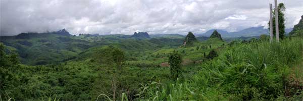
| 1. View from Highway 13
|
|
 |
 |
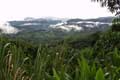
| 2. Buying corn
|
|
|
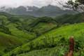 |
| 3. Rice fields
|
|
|
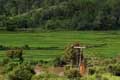 |
| 4. Water wheel
|
|
|
|
|
|
Highway 13 is the primary land route through Laos. It runs from China in the north to Cambodia in the south — virtually the entire length of the country. In the mountainous north, the scenery along the way is absolutely stunning (see photo #1, at left and the panorama, above). Until very recently, the road was in terrible condition. It was barely passable in many places, with bridges washed out or unusable, landslides in the mountains, and potholes everywhere. Traveling even short distances took hours. During the last few years, the Lao government has made a major effort to improve its roads, and Highway 13 is now in excellent condition.
We hired a driver and van in Luang Prabang to take us first to Phonsavan for 2 days and then on to Vang Vieng. Most of the trip was through very rugged mountains. The road rises and falls constantly, and twists and turns as it follows the contours of the mountain sides. It was very slow going, and we spent 6 hours or more on each leg of our journey. Along the way, our driver stopped to buy some steamed corn (photo #2). The corn is grown locally and the kernals are a mix of colors from white to purple. The ears are small and very sweet. They are steamed in the husks and make a convenient, satisfying snack.
The soils in these northern mountains are not very fertile, and the farmers traditionally grew rice and corn for only a few years before moving to new fields. They would allow the soil to remain fallow for 15 years or more before returning to plant it again. Now the population is increasing and the farmers are being forced to cut down the forests to bring more land into cultivation (photo #3). Much of this new land is really too steep, and the soils are too erosive, for farming. Without the stabilization of the tree roots, many of the mountain sides are beginning to erode. The government has outlawed this deforestation, but the people are too poor to buy food and would starve without the additional acreage, so they go on cutting the forests. This is typical of similar problems in poor countries throughout the world.
Part of our trip was on Highway 7 through Xieng Khoang Province. Along the way we saw a really huge undershot water wheel (photo #4). The force of the stream pushes the water wheel around, and small containers around its edge collect water as they dip into the stream. If you look closely, you can see the full containers emptying into a large reservoir near the top of the wheel. This water is then carried by a hose up the hill to fill a pond that is then used for irrigation. This ancient technology is quite ingenious, and makes sense in this location where there is no electrical power available. (Otherwise it would be cheaper, easier, and more reliable to use an electric powered pump to do the same thing — which of course is why this is the first water wheel we've seen anywhere on our travels.)
Another important part of the Highway 13 story is to mention the armed attacks on buses and other travelers who are making their way through an area just south of Phou Khoun. Several buses have been attacked, with dozens of deaths, over the last 2-3 years. A few of the dead were foreign tourists. Local Hmong tribesmen are apparantly still fighting their war with the Communist Lao government after all these years. (The government attributes the attacks to "bandits", which may be at least partly true.) As we passed through this area, we saw quite a few Hmong men along the roads carrying AK-47 assault rifles. We also passed a bus that had been gutted and abandoned along the road. We were aware of the potential danger, but not particularly concerned. We felt that our risk of being killed or injured in a traffic accident were considerably greater than our risk of being attacked by "bandits". About 50 kilometers south of Phou Khoun, our driver told us that we had left the danger area, and could now relax. But, we were still on a twisting road with no guardrails and precipitous drops, and did not relax until we left the mountains for the relatively flat terrain of the Song River Valley, which is pictured in the panorama photo at the top of this page.
— return to the 2004 Journal Archive
|